
Crêt de la Neige
(Redirected from Crêt De La Neige)
| Le Crêt de la Neige | |
|---|---|
 Le Crêt de la Neige in Thoiry (Ain) | |
| Highest point | |
| Elevation | 1,720 m (5,640 ft)[1] |
| Prominence | 1,260 m (4,130 ft)[2] |
| Parent peak | Mont Blanc |
| Isolation | 41.3 km (25.7 mi)[3] |
| Coordinates | 46°16′15″N 5°56′22″E / 46.27083°N 5.93944°E |
| Geography | |
 Le Crêt de la Neige France | |
| Location | Ain, Rhône-Alpes, France |
| Parent range | Jura Mountains |
Le Crêt de la Neige is the highest peak in the Jura Mountains and the department of Ain in France. Its elevation is 1720 m above sea level (reported as 1718 m before 2003). Its prominence is 1260 m. It is located in the commune of Thoiry. In 2024, a team of researchers locates the actual highest peak in a protected area and measures its elevation at 1720,83 m, while they found the geodetic marker at Crêt de la Neige at 1718,06 m elevation[4].
-
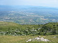 Looking towards Geneva from the summit
 -
 Summit of the Crêt de la Neige, with Le Reculet in the background


References
[edit]- ^ Retrieved from the IGN topographic maps [1]
- ^ Retrieved from the Swisstopo topographic maps [2]. The lowest col between the Jura and the Alps is located at the Canal d’Entreroches (in Switzerland), at approximately 460 metres above sea level.
- ^ Retrieved from the Swisstopo topographic maps. The nearest point of higher elevation is northwest of the Montagne de Sous Dine.
- ^ Hetényi G., Chagros A.-M., Lemke K., Maharaj A., Baron L. (2024). Détermination du point culminant du massif du Jura. Mémoires de Géologie (Lausanne), n° 51, 6pp. [3]
| International | |
|---|---|
| National | |
This Ain geographical article is a stub. You can help Wikipedia by expanding it. |