Richland, Georgia
Richland, Georgia | |
|---|---|
 | |
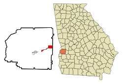
 Location in Stewart County and the state of Georgia | |
| Coordinates: 32°5′19″N 84°39′50″W / 32.08861°N 84.66389°W | |
| Country | United States |
| State | Georgia |
| County | Stewart |
| Area | |
• Total | 3.25 sq mi (8.40 km2) |
| • Land | 3.20 sq mi (8.29 km2) |
| • Water | 0.04 sq mi (0.12 km2) |
| Elevation | 607 ft (185 m) |
| Population (2020) | |
• Total | 1,370 |
| • Density | 428.13/sq mi (165.28/km2) |
| Time zone | UTC-5 (Eastern (EST)) |
| • Summer (DST) | UTC-4 (EDT) |
| ZIP code | 31825 |
| Area code | 229 |
| FIPS code | 13-65016[2] |
| GNIS feature ID | 0356496[3] |
Richland is a city in Stewart County, Georgia, United States. Per the 2020 census, the population was 1,370.[4]
History
[edit]The community took its name from the local Richland Baptist Church, the name of which most likely is a transfer from Richland, South Carolina, the native home of a large share of the first settlers.[5] The Georgia General Assembly incorporated Richland in 1889.[6]
Geography
[edit]Richland is located along U.S. Route 280 and Georgia State Route 520 (known as South Georgia Parkway). U.S. Route 280 and Georgia 520 lead northwest 36 miles (58 km) to Columbus. The two highways separate in the city, with U.S. Route 280 leading east 29 miles (47 km) to Americus and Georgia 520 leading southeast 52 miles (84 km) to Albany.
According to the United States Census Bureau, the city has a total area of 4.2 square miles (11 km2), of which 4.2 square miles (11 km2) is land and 0.04 square miles (0.10 km2) (0.48%) is water.
Demographics
[edit]| Census | Pop. | Note | %± |
|---|---|---|---|
| 1890 | 457 | — | |
| 1900 | 1,014 | 121.9% | |
| 1910 | 1,250 | 23.3% | |
| 1920 | 1,529 | 22.3% | |
| 1930 | 1,577 | 3.1% | |
| 1940 | 1,497 | −5.1% | |
| 1950 | 1,571 | 4.9% | |
| 1960 | 1,472 | −6.3% | |
| 1970 | 1,823 | 23.8% | |
| 1980 | 1,802 | −1.2% | |
| 1990 | 1,668 | −7.4% | |
| 2000 | 1,794 | 7.6% | |
| 2010 | 1,473 | −17.9% | |
| 2020 | 1,370 | −7.0% | |
| U.S. Decennial Census[7] 2010[8] 2020[9] | |||
| Race / Ethnicity | Pop 2010[8] | Pop 2020[9] | % 2010 | % 2020 |
|---|---|---|---|---|
| White alone (NH) | 408 | 345 | 27.70% | 25.18% |
| Black or African American alone (NH) | 1,013 | 967 | 68.77% | 70.58% |
| Native American or Alaska Native alone (NH) | 3 | 2 | 0.20% | 0.15% |
| Asian alone (NH) | 8 | 4 | 0.54% | 0.29% |
| Pacific Islander alone (NH) | 0 | 0 | 0.00% | 0.00% |
| Some Other Race alone (NH) | 0 | 0 | 0.00% | 0.00% |
| Mixed Race/Multi-Racial (NH) | 8 | 40 | 0.54% | 2.92% |
| Hispanic or Latino (any race) | 33 | 12 | 2.24% | 0.88% |
| Total | 1,473 | 1,370 | 100.00% | 100.00% |
At the 2020 census, its population was 1,370.
Notable people
[edit]- Birthplace of Lillian Gordy Carter, mother of former president of the United States Jimmy Carter
- Jarvis Jones, Retired NFL linebacker for the Pittsburgh Steelers
- Steve Sanders, child actor and vocalist for Oak Ridge Boys
Gallery
[edit]-
Built in the 1890s and renovated in 2008, the Richland Depot now serves as the city hall. The building was listed on the National Register of Historic Places as a contributing property to the Richland Historic District on May 5, 1986.
-
Richland Post Office (ZIP code: 31825)
-
East of Richland, the Nathaniel Prothro Plantation was the largest cotton plantation in Stewart County at the beginning of the Civil War. The Greek Revival main house was built by 1851 by Dan E. Ponder. It was listed on the National Register of Historic Places on May 2, 1985.
-
The Dr. Thomas B. Miller House was listed on the National Register of Historic Places on March 2, 1988
-
Bessie Lillian Gordy Carter, mother of Jimmy Carter, 39th President of the United States, was born and raised in Richland.
References
[edit]- ^ "2020 U.S. Gazetteer Files". United States Census Bureau. Retrieved December 18, 2021.
- ^ "U.S. Census website". United States Census Bureau. Retrieved January 31, 2008.
- ^ "US Board on Geographic Names". United States Geological Survey. October 25, 2007. Retrieved January 31, 2008.
- ^ "Richland city, Georgia". United States Census Bureau. Retrieved April 15, 2022.
- ^ Krakow, Kenneth K. (1975). Georgia Place-Names: Their History and Origins (PDF). Macon, GA: Winship Press. p. 188. ISBN 0-915430-00-2.
- ^ Candler, Allen Daniel; Evans, Clement Anselm (1906). Georgia: Comprising Sketches of Counties, Towns, Events, Institutions, and Persons. State historical association. p. 195.
- ^ "Decennial Census of Population and Housing by Decades". US Census Bureau.
- ^ a b "P2 Hispanic or Latino, and Not Hispanic or Latino by Race – 2010: DEC Redistricting Data (PL 94-171) – Richland city, Georgia". United States Census Bureau.
- ^ a b "P2 Hispanic or Latino, and Not Hispanic or Latino by Race – 2020: DEC Redistricting Data (PL 94-171) – Richland city, Georgia". United States Census Bureau.


